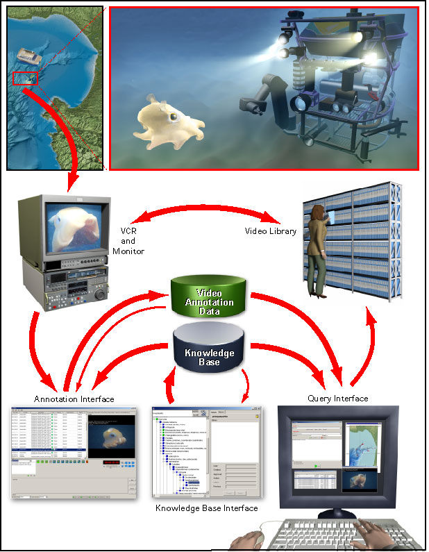
System Overview of VARS at MBARI
MBARI uses standard-definition (SD) and high-defiition (HD) video equipment to record more than 300 remotely operated vehicle (ROV) dives per year. From 1989 to 2003, 14,000 videotapes were archived, annotated, and maintained as a centralized institutional resource. This video library contains detailed footage of the biological, chemical, geological, and physical aspects of the Monterey Bay submarine canyon and other areas including the Pacific Northwest, Northern California, Hawaii, and the Gulf of California. The Video Annotation and Reference System (VARS), consisting of software and hardware, was developed to facilitate the creation, storage, and retrieval of video annotation records from the ROV dive tapes.
As shown in the flowchart below, video images are collected by cameras on ROVs (remotely operated vehicles). The actual recordings are made in the shipboard control rooms. Using the Annotation application, researchers take frame grabs and enter annotations during the dives. Annotation descriptions are created using the extensive knowledge database. When a ship returns to shore, the tapes are reviewed and annotated in more detail by video lab personnel, also using the Annotation application. All of this information goes into the annotation database, and a copy of the completely annotated tape is stored in the video library. At this point, the information is now accessible through the Query application.

VARS Knowledgebase
The core of the system is a knowledge database of over 3,000 biological, geological and technical terms used to describe deep-sea research conducted by the institute. This database is comprised of objects, which are identifiable things—for example, Atolla wyvillei jelly, fault, myctophid fish, gas vent, or suction sampler. The knowledge base also contains associations, which serve as descriptors (such as blue, large, juvenile, or active) that can be associated with the objects being analyzed. The taxonomic data can be viewed in alphabetic or hierarchical order and is accompanied by descriptive information that serves as a marine reference guide for system users. The hierarchical information allows for consistent, rapid classification and description and complex querying of objects observed on video.
The Knowledgebase application allows science personnel to easily add, view, and edit information contained in the knowledgebase. To ensure consistency, all amendments must be authorized by a knowledge base manager. Functioning as an encyclopedia, the knowledgebase is used with the annotation application to characterize video observations in a consistent fashion.
VARS Annotation
The Annotation application allows researchers on the ships to make annotations of objects and events observed in the video, as it is being recorded by the ROV cameras. However, it is rarely possible to get all the details recorded in real-time. The view through the camera is constantly changing, and a variety of creatures (and other objects) appear and disappear with great frequency. Every tape is later viewed in the video lab, and the rest of the details are added to the annotation database by video lab personel.
The instructions and documentation on these pages are presented for those who might be using the interface on a cruise or doing research in the MBARI video lab.
Documentation and instructions for VARS annotation interface
VARS Query
The VARS Query allows easy access to information from a video annotation database. Complex queries can be made by constraining temporal, spatial, or physical parameters (for example: season, location, or depth). The VARS Query references the knowledgebase (described above). Using the query tool, users can identify the location of video sequences or access other information recorded during ROV research dives.
Use VARS Query to access MBARI's publically available data
Data disclaimer
Though they have proven to have great inherent and inferred scientific value, the data were not always collected using systematic search procedures. Biases have been introduced by observation techniques, camera settings, mission planning, changing science terminology, and observation location and sequencing, among other factors. In no way should these data be viewed or analyzed as random, structured, or systematic observations.